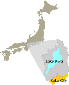
About Koka: City Profile
As of March 31, 2008, the City of Koka has a reported population of 95,683 and 31,891 households. We are a growing community and project a population of over 100,000 by 2014.
The City of Koka, covering 43.8 km laterally and 26.8 longitudinally, has an area of approximately 481.69 km making it 12% of Shiga Prefecture.

The City of Koka is located approximately 40 km (about 25 miles) east of Kyoto City. Located within 100 km (about 62 miles) of Osaka and Nagoya in the southeastern portion of Shiga, Koka is set within the gateway between the Kinki and Chubu regions in Japan. The southeastern section of Koka is encompassed by the Suzuka Mountain Range, with many peaks reaching over 1000 meters, (3280 feet). The southwestern portion of Koka borders both Mie and Kyoto Prefectures. Much of the rest of the city is low and flat, with forests, greenery, and rivers.
Koka City experiences four distinct seasons, with warm summers, cool winters and a mild spring and autumn.
- Average Annual Temperature
- 12-14℃ depending on the region
- Average Annual Rainfall
- 1,500-1,600mm (about 61 inches)
- Average Annual Snowfall
- 20-30cm (about 8 inches)
The city’s railway system includes the Japan Railways (JR) Kusatsu Line; as well as the Omi line and Shigaraki-Kogen line, which both begin at the JR Kibukawa Station.
As for the highway system, the most important main road includes National Highway 1 (Koku-do 1-go) as well as the local Kusatsu-Iga Highway (Shuyo-chihodo Kusatsu-Iga Sen), and National Highway 307 (Koku-do 307-go). Another recent major infrastructural addition to our area includes the Shin-Meishin Expressway (Shin-Meishin Kosokudoro), with currently two interchanges located within city limits: Koka-Tsuchiyama and Shigaraki. The Konan interchange is projected to be opened in the near future.
Access to Koka City